About Us
Who Protects Water?
Rights of Nature
The first 20 years
Awards
Photo Gallery
Membership Info/Renew
Contact Info
Email Updates
Directors & Officers
Committees
News and Information
Newsletters
Board agendas & meeting notes
Invasive Plant Information
Volunteer!
Water Quality - SSR
Like us on Facebook
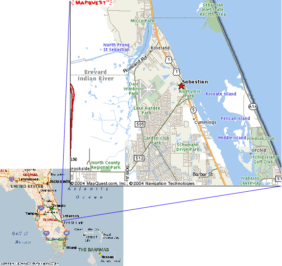
The St. Sebastian River
. . . is one of the few remaining coastal rivers in East Florida which has not been heavily developed. It is home to a wide variety of wildlife, including several endangered species. Eagles, otters, dolphins, woodstorks, alligators, and several kinds of wading birds can be observed along the river. The upland area includes habitat for other rare creatures, including the Gopher Tortoise and Florida Scrub Jay. The river is home to many game fish such as tarpon and snook, and a few rare and endemic fish species.
Endangered West Indian Manatees can be found here during any season, and the river is a year-round designated slow speed zone. At times, over one hundred manatees congregate in the St. Sebastian River. Recognizing the river's importance to the survival of the manatee as a species, the State of Florida has purchased large pieces of property with shoreline and uplands along the river.
The winding river is perfect for canoeing and fishing. In some places, the untouched shoreline offers a view of wild Florida as it used to be. Guided tours are available by canoe, kayak or powerboat. There are public parks and boat ramps.
As population increases, we will need to take special care of this beautiful resource. In spite of its beauty, there are problems. Water quality must be improved. Discharge of excess freshwater and nutrients from development and agricultural lands is a major concern. Manatees and other endangered species need better protection.
The Friends of St. Sebastian River has become an effective voice for conservation. With broad community support, we hope to take good care of our river and protect it for future generations to enjoy.
What's in a Name?
There has been a great deal of discussion about the name of our river. Most people when they arrive here are told that it is the Sebastian River. However, the official name is the St. Sebastian River. George Keyes researched this subject, and on December 21, 1988, the U.S. Board of Geographic Names approved the names "Saint Sebastian River, North Prong Saint Sebastian River, and South Prong Saint Sebastian River." Here is the information he submitted to obtain this ruling:
This historical name of our river is described by Bernard Romans, cartographer for King George III, in his book, A Concise Natural History of East and West Florida, "the shore stretches nearly south, to opposite the mouth of the Saint Sebastian River in lat. 27° 56"... in the lagoon and sound many streams of fine fresh water empty themselves; the principal are the rivers St. Sebastian and St. Lucia as the map showes (sic). Romans' 1774 map shows the river as the San Sebastian River."
Don Andres Burgevin surveyed the 20,000 acres of the Fleming Grant for the Captain of the Spanish Militia, Don George Fleming, by decree of the Spanish Government, made June 8, 1819. The entrance to the grant is shown as the St. Sebastian River.
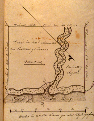
This image is of the survey done of Fleming's Grant by the King of Spain, c.1828. The diagonal line, from upper left to lower right, is the North compass alignment. At the bottom is the Indian River Lagoon, noted as "Rio de Ays." At the mouth of the St. Sebastian River, its name is noted as "Rio de S. Sebastian."
United States. Board of Land Commissioners. Fleming, Geo. . State Archives of Florida, Florida Memory. https://www.floridamemory.com/items/show/232645.
From the book Observations Upon the Floridas by Charles Vignoles, published in 1823, we find the river mentioned, "Five miles below the mouth of the St. Sebastian river (sic), distant altogether eighteen miles from the south end of Meritt's (sic) island, and distinguished by a high red sand bluff on the south point of entrance, the stream like the preceding ones has pine lands alone on its banks, etc."
James Gasden surveyed for a road from St. Augustine to Cape Florida for the U.S. Army along the east coast in 1825. In his report to the Quartermaster General he mentions the names of the principal rivers as obstructions to the opening of a road; on the list is the St. Sebastian. He also mentions that a ferry would be necessary on the St. Sebastian River as it was not fordable.
During the Second Seminole War, Lt. Powell of the Navy, attached to the 1st Reg. of Artillery under the command of Lt. Col. Benjamin Pierce, was ordered down the Indian River with 33 small light boats with two hundred men, with a mixed group of soldiers, sailors and volunteers. On Dec. 28, 1837, they camped on a high oak bluff on the north bank of the St. Sebastian River where they were to ascend at night looking for indians (sic).
Following the Third Seminole War, often called the Bowlegs War, we found that Andrew Canova, discharged from the Florida Volunteers, had built a thatched hut near the mouth of the St. Sebastian River where he lived with Ed. (sic) Marr for three years until he went to St. Augustine to join the Confederate Army in 1861.
Dr. James Henshall from Cynthia, Ky, made three trips to our local river during the years of 1879-1881, in his book Camping and Cruising in Florida he states, "the St. Sebastian from its mouth to this point is from a fourth to one half mile in width, and a mile long. Here it seperates (sic) into the North, West and South Prongs."
In 1889, Dr. Frank Chapman, from the American Museum of Natural History, ascended the South Prong to the headwaters of the St. Sebastian River while on a search for Carolina Paroquets. We find Chapman's description of the river from a paper read (sic) 1 November 1889. "The St. Sebastian River is a beautiful river; no words of mine can adequately describe it. Half mile wide at its mouth, it narrows rapidly, and three miles above appears as a mere stream, etc.
Sylvanus Kitching wrote to his friend in England on Feb.11, 1898, "Yesterday a party of over twenty of us went out on the St. Sebastian River on a fishing picnic."
When Indian River County was formed in an Act of the Legislature, Session 1925, Chapter 10148 (no.126), Approved May 30, 1925, some of the description reads in part, "line intersects the medial line of the South fork of the St. Sebastian River; thence Northerly down the middle of said stream to the main stream of the St. Sebastian River; thence down the middle of the St. Sebastian River to its confluence with the Indian River, etc."
After the Sebastian Area Historical Society was founded in 1985 we found a variety of names had been in use for our local river. Some were Sebastian Creek, St. Sebastian Creek, Sebastian River, San Sebastian River, San Sebastian Bay, and St. Sebastian River. On Nov. 1, 1988, the historical society filed a request with the United States Department of Interior, Board of Geographic Names for a correction to restore the original historic name St. Sebastian River, located in Latitude 27°, 15" and Longitude 80° 29'29"W.
The society received a reply from the Board on Nov.15, 1988 which states "This will acknowledge your proposal to have the name Saint Sebastian River made official for Federal maps and other publications. This proposal has been submitted to the Board on Geographic Names by the National Ocean Service, and the name is on the docket for Board consideration."
On Dec.21, 1988, a letter was sent to the society from the United States Board on Geographic Names which states, "We are pleased to inform you that the Board on Geographic Names, at its Dec. 8, 1988 meeting, approved the names Saint Sebastian River, North Prong Saint Sebastian River and South Prong Saint Sebastian River. These names will be published in Decision List 8804."
On Sept.18, 1989, the Indian River County Board of County Commissioners approved the corrected name St. Sebastian River. In November 1993 Indian River County, through the efforts of the Friends of the (sic) St. Sebastian River, placed signs at both ends of the bridge on CR 512 which indicate South Prong St. Sebastian River.
The Intracoastal Waterway chart #11472, published by the U.S. Department of Commerce, National Oceanic and Atmospheric Administration, National Ocean Service, corrected in 1991, now records the Saint Sebastian River instead of the old designation Sebastian Creek. The signs on the US 1 bridge over the same body of water remained Sebastian River until about 1994 when the Florida Department of Transportation changed the signs to read St. Sebastian River.
Dolph Map Co. of Fort Lauderdale, Florida, corrected their road maps in 1991 to read St. Sebastian River. Dolph Map Co. now does the printing for Rand McNalley (sic).
George Keyes, Sebastian Area Historical Society
What is a watershed?
National Oceanic and Atmospheric AdministrationIt's a land area that channels rainfall and snowmelt to creeks, streams, and rivers, and eventually to outflow points such as reservoirs, bays, and the ocean.
While some watersheds (also called drainage basin or catchment) are relatively small, others encompass thousands of square miles and may contain streams, rivers, lakes, reservoirs, and underlying groundwater that are hundreds of miles inland.
The largest watershed in North America is the Mississippi River Watershed, which drains 1.15 million square miles, from all or parts of 31 U.S. states and two Canadian provinces. You will find a fun, animated graphical representation of this watershed on the NASA website at https://svs.gsfc.nasa.gov/4493.
Watersheds are important to both water quantity and quality, as they "shed" whatever is picked up in the process of draining stormwater to the nearest waterbody. As a result, buffers to the waterbody are one of the best ways of protecting water quality, by catching or absorbing pollutants.
In the United States, forests have historically been viewed to have a positive effect on water resources. This view is backed up by decades of research that confirms that forests (including managed forests) provide the highest-quality and most reliable freshwater supplies among all other land uses (Journal of Forestry, Volume 117, Issue 1, January 2019, pages 80-85). In addition, you may be interested in a great educational booklet from the USDA entitled Water & Forests - The role trees play in water quality
Streamside forests capture, absorb, and store amounts of rainfall up to 40 times greater than disturbed soils, like agricultural fields or construction sites, and 15 times more than turf grass (Keystone 10 Million Trees Partnership, Ten Million Trees for Pennsylvania).
For a more in-depth explanation of what a watershed is, you may be interested in the information on the U.S. Geological Service's website at www.usgs.gov/special-topics/water-science-school/science/watersheds-and-drainage-basins. In addition, the USGS provides specific water flow, discharge and gage height data, along with a map showing a crude representation of the watershed, for the St. Sebastian River here.
The US Geological Survey also has an interactive map called River Runner Visualization. The map allows you to click anywhere to drop a virtual raindrop, and a visualization of the watershed where that drop of rain will drain to.
The University of Florida, Institute of Food and Agricultural Sciences also has lots of information about Florida watersheds on their webpage at Watersheds - Functions and Management.
And here's 10 Things You Can Do to Protect a Watershed, Nile Mile Creek Watershed District, MN.
After The Storm - What is a Watershed and How to Protect It, EPA and The Weather Channel
St. Sebastian River Watershed
Watersheds in Florida are a complicated issue as many have been dramatically altered over the years from drainage projects intended to drain the land for agriculture and/or development. The most well-known, perhaps, are the Kissimmee River and the Everglades, which were ditched, channelized and drained. The state of Florida and the federal government have spent billions of dollars on restoration efforts to undo projects that were once designed to drain what was thought to be a wasteland, and provide for "improvements."The St. Sebastian River watershed has been greatly altered by canals, ditches and development, as well, thus it is hard to find an accurate representation of the extent of our River's watershed. A partial representation of it may be found on the EPA's "How's My Waterway?" web page. This website may also be accessed, with the zip code of your specific "waterway" entered, on the "How's My Waterway" widget on the home page of our website.
Just remember, wherever you live, you are in a watershed and, therefore, your choices and actions affect our waterways! Please take note and remember those signs we all see here and there - "only rain down the drain" and "all canals lead to the lagoon!"
What is a slough?
National Oceanic and Atmospheric AdministrationA slough is a swamp or shallow lake system, usually a backwater to a larger body of water. It is typically used to describe wetlands. Sloughs along the edges of rivers form where the old channel of the river once flowed. These areas are also referred to as oxbows because they tend to form at a bend in the old river bed, making them look like the U-shaped collar placed around the neck of an ox to which a plow is attached.
Did you know?
While this term is used differently across the country, on the West Coast a slough is referred to as a swamp or shallow lake system, usually a backwater to a larger body of water.
Slough is typically pronounced "slew" in most of the United States. In New England, you may hear it pronounced in a way that rhymes with "cow" – this is the preferred British pronunciation. You may also hear this word pronounced as "sluff." With this pronunciation, slough has a different meaning.
For a full description of what a slough is, visit the NOAA website here.